

Quay County
NMGenWeb

"I, Don Pablo Montoya, most humbly present myself before Your Excellency, and state that, being the owner of a certain amount of stock such as cattle, sheep and horses, and requiring pastures and capacity for its increase, having registered a piece of land without any individual owner, or belonging to any community, with the necessary supply of water, pastures and timber, removed from any settlement which could in any manner by injured; the location of which is on Red River, from the Rincon de la Cinta to the Trinchera, within which limits no individual of the territory pastures and stock, not reaching that far on account of its distance; its entire extent in the other two directions being from the Arroyo de Cuervo to the Mule Spring; and Your Excellency possessing all authority to make grants according to the wants of the people, and which result to the benefit of the territory and to every citizen, and in consideration of the superior intelligence of Your Excellency, which will perceive the benefits which will result to me, as well as by this means the immense tracts of land in which our territory abounds will be occupied, and the savages will be made to know the strength of this powerful nation. In view of such just and rational motives, I pray Your Excellency to condescend to accede to my petition by doing which I will be benefited and receive grace, swearing, in due form, that I do not act in malice."
Above is the letter to the territorial authority written in Santa Fe on November 8, 1824, three years after Mexico had gained its independence from Spanish dominion. Montoya's petition was granted only 12 days later, on the 20th day of November 1824. The Pablo Montoya Land Grant was created which contained 655,468 acres. A few years later this Pablo Montoya Land Grant was to become the Bell Ranch.
Wilson Waddingham, a Canadian, showed up in New Mexico ca. 1870 and he ended up in control of the Pablo Montoya Grant. He also acquired the Baca II Grant and several ranches around the grants. Waddingham also gave the ranch its name after a butte in the shape of a bell near ranch headquarters. This bell-shaped butte has been an area landmark from the earliest sighting of it by the Spanish. From the beginning it was referred to it as "la campana," The Bell. The "Bell" brand was recorded in San Miguel County, New Mexico Territory, on March 15, 1875 by Wilson Waddingham.
From 1890 due to falling cattle prices, persistent drouth and unable to borrow more money, Wilson Waddingham lost control of The Bell. Ezekiel G. Stoddard an Eastern banker, and Edward Bradley formed the Red River Valley Co. and took control of The Bell. The Red River Valley Co. controlled The Bell from 1899 until it was sold in 1947. During these fifty years The Bell enjoyed a period of stability that it had not known.
In 1947, some new owners, Ed T. Springer of the Charles Springer Cattle Company, Cimarron, New Mexico and Louis Stoddard divided the more than 400,000 acres remaining in the Bell Ranch into six segments and they sold the segments. The last of the giants was gone. A segment of The Bell ranch still continued but it was small compared to the giant it once was. To this day the bell-shaped butte can be seen as a reminder of things the way they were.
Bell Ranch as I Knew It by George F. Ellis.
New Mexico Place Names by T. M. Pearce, 1965.
New Mexico, American Guide Series, 1940, by the Coronado Cuarto Centennial Commission.
Written and contributed by Harold Kilmer

 The "BLUFFS OF LLANO ESTACADO," called the CAPROCK by locals, is
located between Clovis and San Jon, New Mexico.
The "BLUFFS OF LLANO ESTACADO," called the CAPROCK by locals, is
located between Clovis and San Jon, New Mexico.
Above picture is taken from the Valley and is looking up to the top of the caprock. Clovis is on top of the caprock.
Right picture is from top of caprock looking down into the valley.
Early settlers hauled firewood and cedar post from the caprock for use on the High Plains.
Pictures taken by Don McAlavy. Contributed by Harold Kilmer
"A trading point for ranchers on the Rock Island Railroad near the Canadian
River. 24 miles northeast of Tucumcari, New Mexico. It was named for Captain H.
Logan, a Texas ranger who had filed a claim on this site. Also, on New Mexico 39
and US 54. Has had a post office since 1901.
"Logan was nearly a ghost town
when Ute lake was built on the Canadian below where Ute creek joined it. Logan
is now (1997) a fishing resort town. It is going strong again."
--Harold
Kilmer
The following article was written by Sim McFarland in 1910 on McFarland Brothers stationery for advertising purposes
Logan is situated on the north bank of the Canadian River on the main line of the Chicago, Rock Island and Pacific Railroad, Highway 54 and 39, Chicago to Los Angeles. It is 200 feet higher than the river bed, never overflowing and mosquitoes are never heard or seen.
Logan's first house was built in 1901, and the town has a gradual but slow growth, until now it has a population of about 300.
We have an eight month's school. The assessed valuation of our District is $195,000.00. We are voting bonds for a $6,000.00 school house.
We have three Churches organized here. The Missionary Baptist, M.E. South, and Catholic. They are fixing to build a $1,500.00 Baptist Church soon.
We have three lodges, the Masons, Odd-fellows and Woodmen.
Our main crops planted are corn -- not doing much good in the last 2 years, Maize, Kaffa Corn, Beans, Peas, and other garden crops -- fair to good, but the last 2 years are dryer and less crops than any year in 5.
Trees are doing fine. Trees planted 3 years ago would have borne this year had it not been for the frost. All trees have made a good growth.
There is some land to be filed on 8 to 15 miles from town and relinquishments and deeded land can be bought reasonably close in. Stop off and take a look at our country when out looking for land.
Logan was named after an old ex-Texas ranger and United States Marshal, who
was wounded in helping move the Marlow boys from one jail to another, and Logan
came into existence when the Chicago, Rock Island and Pacific Railroad came down
to build the railroad bridge. J.H. Conlin was superintendent and M. Bishop was
superintendent of bridge construction. The only special mark at this time was a
little cedar tree on the north bank of the river.
The townsite of Logan
was filed on by Olie E. Smith, a Clayton attorney, by Power of Attorney from
Wiliam Kirkpatrick, an old Union soldier, under a law that gave the old Union
soldiers a right to sell their homestead rights by what they called script.
Olie E. Smith complied with the law to prove up on this eighty acres of the
townsite and received patent for William Kirkpatrick dated June 22, 1904.
Olie E. Smith, by Power of Attorney by William Kirkpatirck and Nancy
Kirkpatrick, his wife, sold the townsite to M. Bishop and Eugene Logan for the
consideration of $400.00 on August 7, 1901. M. Bishop sold his interest to J.E.
Johnson.
The streets and alleys were dedicated to the public by J.E.
Johnson November 15, 1901, by filing map with the County Clerk of Union County,
as we were in Union County at that time.
Streets running east and west
are 100 feet wide and streets running north and south are 80 feet wide. The name
of the north street running east and west is Gallegos Street, the second Street
running west from the depot is Martinez Street, the next street south is Armijo
Street, the next is Garcia Street, and the next is Vigil Street, and the next is
Fuentez Street.
The first street on the east edge of the townsite is
First Street, the next is Second Street, the next is Third Street, the next is
Fourth Street, and the fifth Street being on the west edge of the townsite being
40 feet, but later made 40 feet more by the west land owners.
This is the
history of Logan until lots were sold to various parties.
The first
merchant was John Burns. The first school teacher in Logan was Miss Petra
Gallegos of Clayton, teaching one month at Logan (in a 16 by 24 frame building),
one month at Bryantine, and one month at Gallegos. The Second teacher was
Elatorio Baca, and the third teacher was W. W. Moore.
Nepomoseno
Martinez, father of Manuel Martinez, was one of the first school board members.
The first school house was built in Logan in 1901 and is now one of the
Hilly buildings. The first part of the present school building was built in 1910
and the members of the school board were Sim McFarland, E. L. Merrill, and J.H.
Shollenbarger.
The first postmistress was Mrs. John Burns. W. L. Besse
was the first resident depot agent. The first resident railroad pumper was Tom
Goodrich and the first railroad section foreman was J.W. Furlow. The first
merchant was John Burns. The first resident doctor was Abijah Jones.
The
First church was the Baptist Church built in 1910. The first religious services
in Logan was Sunday School conducted by Mr. and Mrs. W. L. Besse in 1902 in the
lobby of the depot. Mr. Besse was railroad depot agent.
The first plot
used for a cemetery was located on the Mariana Montoya place now owned by J. D.
Meeks. The present cemetery was filed on by the First Baptist Church of Logan in
1910. The first party buried on it was Waddie Peacock, an old L.S. cowpuncher,
on Lot 1, Block 4.
The first lumber yard was owned by Fox-worth Lumber
Company, operated by W.L. Besse, later purchased by Shollenbarger and Woodard.
The first blacksmith shop in Logan was owned by D. W. Clark.
The
first water well in town was the Charlie Meeks well owned then by Jeff Woodard,
furnishing water for everybody in town.
You will note that the patent for
this land was issued June 22, 1904, and the land was sold by Kirkpatrick to M.
Bishop and Eugene Logan August 7, 1901. When final proof was made on this land
the Government issued a blue print and the patent followed later.
Now
with our new highway bridge and the prospects for irrigation water wells, the E.
Goggins well about a mile northwest of town and the R. N. Rogers and Thurman
Thomas wells about five miles northwest of town, furnishing plenty of Irrigation
water at about 140 feet, and the Dunes Dam which will back water up to about
Logan, we hope that the ambitions of the original owner, M. Bishop, who stated
that you never saw a city amount to anything that was not located on a water
course is now coming true.
Contributed by Don Harrold, who is researching his family history. Don is the Great-Grandson of Sim McFarland.
Roosevelt, New Mexico was located in Quay County four miles southwest of McAlister, New Mexico, near the Roosevelt County line. Roosevelt was founded in 1906 when a townsite was laid out by some realtors who were trying to sell lots. The townsite was bought by Sam Noffsker in 1911. By then there was only a store, a post office operated by a Mr. Clinton Morris, a two story hotel, a few houses, a cemetery and a school. The school consolidated with House in 1919 and the post Office was closed. Postal records show a Roosevelt Post Office 1906 – 1919.

Brush arbor at Roosevelt ca. 1906.
Families include the Reeds,
Elronds, Lorings, Browns, Wootons, Morris and Barrs. Rufe and Alice Choate on right.

J. M. Gilliam home at Roosevelt. Picture from Ruby Adams.

Written on the back of the picture:
James “Jim” and Minnie
Gillam in the alfalfa field east of large elm tree. I have a bunch of Alfalfa on
my hands. See how tall it is. The light streaks Are the wheat fields. The trees
north of that are the trees along the river. These hills are the bluffs on the
north side of the river.

Written on the back of the picture:
This is taken in the field
where they are bringing the hay to the bailer and Jim is hauling it to the train.
Jim, Raymond, Ruth, the man working for us, Jim’s brother Edd, Minnie's mother
Susan Seale Jeter, colored man, Minnie, Mary, and Maude are the people left to right.
Contributed by Ruby Adams. The pictures were taken before 1909.
A ranching and farming community 23 miles east of Tucumcari on the CRI&P RR.
Tom Jones built the first building in 1902.
Construction of the railroad
in 1904 caused the town to boom. It was named in October of 1906 by W. D.
Bennett, the first postmaster, and has had a postoffice since that date.
It is also a Registration Station on I 40 (old US 66).

Just north of the Pajarito Creek, Liberty was founded for the soldiers
stationed at Fort Bascom during the war between the states. When the railroad
built through the country Tucumcari was born. All of the businesses from Liberty
that wanted to survive moved to Tucumcari and this was the death of Liberty.
Fort Bascom had already been closed.
In 1900 the Chicago, Rock Island and
Pacific Railroad decided to build a line across New Mexico to connect with the
El Paso and Northeastern Railroad at Santa Rosa. The line was built in 1901 and
1902. The first passenger train was through Tucumcari March 12, 1902. Soon there
were four passenger trains through Tucumcari each day. Two west bound and two
east bound. There was also a mail train, an express, and at least one freight
train each way every day.
Tucumcari was founded November 22, 1901 on the
Rock Island Railroad in the Territory of New Mexico, Union County. The town was
named for Tucumcari mountain which dominated the landscape. A tent city appeared
almost overnight. J. A. Street is acknowledged as the first person to erect a
tent. Tucumcari was still a tent city in 1903 when Quay County was formed.
There it was. Tucumcari (the Infant Wonder) with no streets, no water, no
sewer; just a railroad and a million dreams. The fathers of Tucumcari would be
the five business men from Liberty who filed on the land, then donated 120 acres
of land for townsite of Tucumcari and were the ones who organized the town in
1901. They were: M. B. Goldenberg, A. D. Goldenberg, Jacob Wertheim, J. A.
Street, and Lee K. Smith.
Wells were dugbut the hard ground and failure
to locate water discouraged drilling wells. Water was not found. Water had to be
hauled each day and delivered to the water barrel by each house. Water would
cost fifty cents a barrel. Some of the men were working for the railroad by
then. The people stayed. They over came the water problem. These people were
real pioneers.
Five million acres of land had been opened for
homesteading. Many people came west with their dreams and hopes only to move on
to greener pastures when they fell victim to the dry arid climate. Dry land
farming just wasn't in God's plan for the area surrounding Tucumcari. Irrigation
came at a latter point in history. The same climate which was a problem for the
farmers was thought to cure tuberculosis. Numbers of people soon arrived hoping
to be cured of TB.
Some of the first businesses to open in 1902 were the
Barnes and Rankin furniture store, the A. B. Simpson hardware, A. A.
Blankenship's livery barn, a hotel , and of course the Monarch Saloon. A
boarding house operated by Mr. and Mrs. Turner was located at First and Turner.
Other businesses swere the Pioneer Bakery, Arcade Restaurant, Waldorf-Astoria
Hotel with rooms for $2 a day, the Owl Saloon, Weldon and Young Real Estate and
Investments, Jackson and Foxworth Lumber Company, and the Exchange Bank. Then
there was the Gross Kelly Company of Las Vegas, offering general merchandise.
The M. B. Goldenberg's Merchantile Company opened. The Berry Brothers Dairy. Max
Goldenberg's home was the first permanent home built in Tucumcari, contained the
post office.
By 1910 there were over 70 business in Tucumcari. There were four doctors and two lawyers. There was always the railroad in the early days. A school system and several churches were very active by 1910.
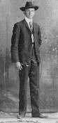
Chester A. Berry
Co-founder of the Berry Brothers Dairy in Tucumcari.
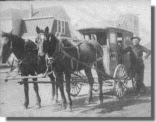
Prentice Berry and the Sunshine Dairy wagon.
Quay County, 1903-1985, by the Quay County Book Committee, published 1985.
Tucumcari and Quay County, New Mexico's best kept secret.
A Mark of Time, A History of New Mexico, by Mary Grooms Clark, published 1983.
High Plains History of East Central New Mexico co-edited by Don McAlavy and Harold Kilmer, 1980.
New Mexico, American Guide Series, 1940 , by the Coronado Cuarto Centennial Commission.
Written and contributed by Harold Kilmer
Copyright © 1996 - The USGenWeb® Project, NMGenWeb, Quay County

This page was last updated
08/04/2026